About Our Equipment
GPR Scanner from Proceq Model: GS8000
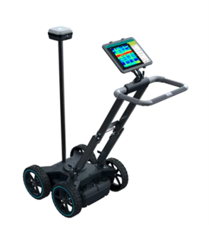
- The all-in-one solution for detecting objects and mapping the underground world using SFCW ground penetrating radar technology.
- Intuitive real-time visualization in 2D and 3D
- Superior data clarity, accurately geo-referenced
- Access to your data from anywhere, anytime
Applications:
Utility strike prevention / Subsurface utility engineering (SUE) / Underground 3D Reality Capture / Asset inspection (bridges, asphalt) / Geophysical investigations / Archeology / Forensics / Precision Agriculture
GSSI Model: SIR-3000
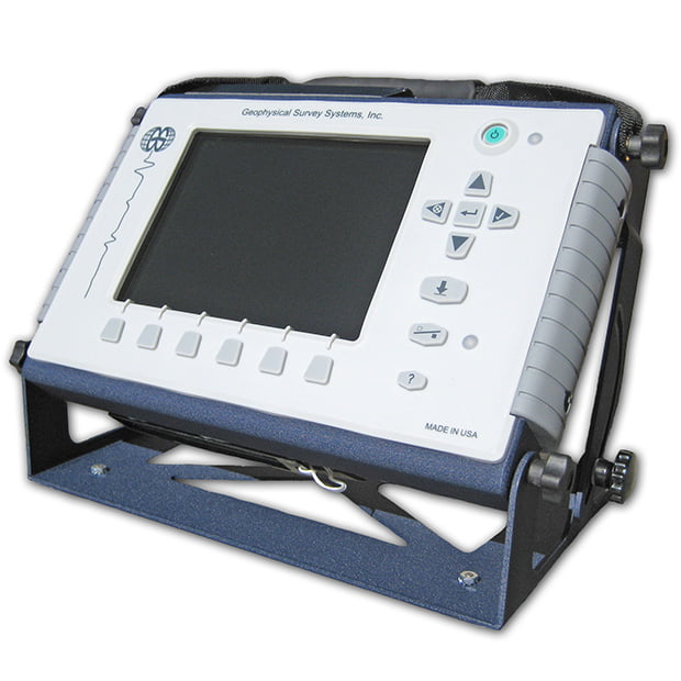
- 400 MHz antenna
- 100-meter control cable
- Image Capacity: Internal: 500 2’x2’ data images
- Internal Memory: 2 GB
- Data collection pad size: 1’x1’, 2’x2’, 2’x4’
- Display: 8.4″, full-color, 800×600 resolution
- 64k colors, clearly visible in sunlight
- Environmental: Water-resistant
The SIR-3000 is the industry’s number one choice for data accuracy and versatility. It is a tool developed to save time, money and even lives.
The SIR-3000 is a small, lightweight system designed for single-user operation. This product provides the essential features and flexibility that experienced GPR users require, as well as simplified, application-specific user interfaces for inexperienced GPR users.
The SIR-3000 incorporates advanced signal processing and display capability for ‘in-the-field’ 3D imaging. Unlike other data acquisition products on the market, the SIR-3000 is interchangeable with all GSSI antennas, making it an affordable and flexible option for multi-application users.
All New GSSI GPR Utility Scan
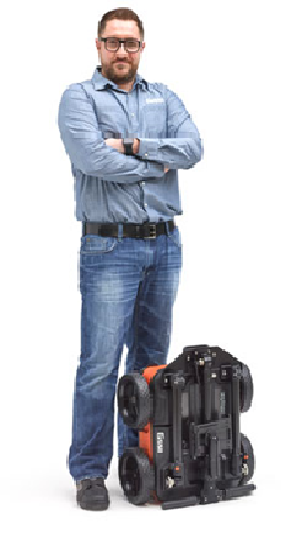
UtilityScan® provides a rich feature set that redefines the level of performance available in a low cost utility locating system. The newly designed UtilityScan combines nearly two decades of utility designation experience with today’s most innovative technology.
The UtilityScan features a wireless and lightweight configuration, our patented HyperStacking technology and integrated LineTrac system. This state-of-the-art system sets the new standard in performance and price.
Locate and detect:
- Water lines
- Utilities
- Voids
- Underground storage tanks
Designate Targets
- Wireless GPR system
- Real-time data presentation and gain control
- Greater depth penetration and clearer data with patented HyperStacking Technology
Advanced Capability
- Detect live power with patented LineTrac technology
- Integrated GPS provided through tablets
- External GPS capability for higher resolution positioning
(user provided) with built-in pole mount
Compact and Portable
- Adjustable handle with dual pivot points for ease of use
- Fully collapsible and compact enough to fit in back of a small vehicle or even an airline overhead compartment
- Only 34 pounds – the lightest and smallest GPR utility locating system on the market
Exceptional Value
- Perfect blend of price and performance
- Complimentary training during the life of the warranty at GSSI headquarters
- Two-year warranty
3D GPR RADAN™ Software
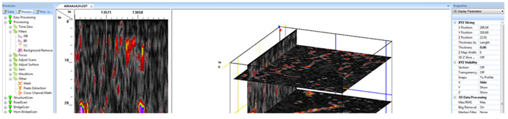
RADAN: The Most Advanced GPR Data Processing Software
RADAN™ is GSSI’s state-of-the-art post-processing software. With its modular design, this program allows users to select the processing functions that best suit their professional needs. RADAN is also Windows™ based, providing a familiar and easy-to-use environment for all levels of experience.
RADAN Benefits
- Familiar, easy-to-use Windows based system
- Easy Processing feature- automated processing wizard that recommends the best processes for cleaning up and improving data
- On-screen help features
- Application specific modules
- Add company logo, when printing directly from RADAN
Advanced Features
- Performance – multiple software threads are able to run in parallel, enabling higher levels of software performance and speed
- Enhanced, easy-to-use 3D capabilities
- Batch Processing – significant enhancements to speed repetitive tasks such as processing large data sets
- GPS and 3D Integration – software will allow easy integration of 3D data sets that have been collected with GPS positioning information, allowing interpolation of non-parallel lines
- AutoCAD Target output – seamless output of interpreted data results to AutoCAD
- Ideal for single- or multi-channel data processing
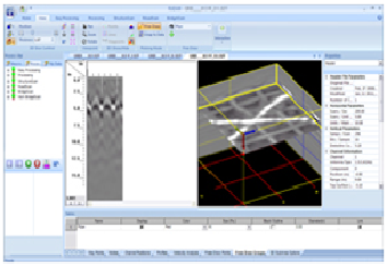
The Next Generation of 3D Mapping is Here: RADAN 7’s 3D module
The 3D module provides enhanced 3D viewing options in a single dialog box. Users can stretch, shrink or zoom in on files as desired for customized presentation results. The 3D module also allows the entire data cube to be “sliced and diced” along various x, y, and z planes. This allows the user to easily interpret complex areas and to make sense of the data. With this module’s simple, intuitive click-and-drag interface, viewing multiple slices and rotating the data for a better view has never been easier.
The 3D module also affords users the ability to show multiple interactive views of 2D and 3D data simultaneously and to create shapes (pipes, drums, lines, etc.) in the GPR data, which can then be exported for integration with CAD drawings. This way, the data can be presented to the client in a familiar, easy to understand format. All of these 3D options provide users with unparalleled data interpretation and presentation capabilities that allow them to showcase their expertise, make better interpretations and get more jobs.
Subsite Utility Locating Equipment from 950R and 950T
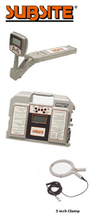
950R TRANSMITTER:
The 950T transmitter places signals on target lines and is used with 950R units. It is configured to send 512 Hz, 1 kHz, 8 kHz, 29 kHz, 80 kHz, and dual (8 kHz and 29 kHz) frequency signals. It places a signal on the line through either direct connection, induction clamping, or sonde modes. Maximum power output is 3 watts. Two power modes allow you to use the correct power for the application, choose low power for short runs where signal bleed off might be a issue, choose high power for longer runs where adjacent utilities don’t exist.
950R RECEIVER:
The 950R lightweight receiver is balanced for easy handling. Enhanced backlit LCD offers optimal visibility in low-light conditions. 950R’s rugged case and sealed keypad withstand tough weather conditions and provide superior moisture resistance issue, choose high power for longer runs where adjacent utilities don’t exist.
Radiodetection Utility Cable and Pipe Locator
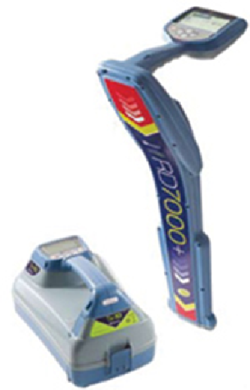
Delivering fast, accurate, reliable and repeatable locate information for all utilities.
Locating specific pipes and cables in large underground networks is becoming increasingly complex. Ground distortion effects, caused by differing soil types and proximity to other conductors, make the operator’s job more difficult and time-consuming. The most important requirements for a locator under these circumstances are ease of use, accuracy and reliability. Radiodetection’s RD7000+ addresses these needs with several ground breaking features that deliver accurate, reliable and repeatable measurements. The new RD7000+ range of locators are powerful successors to the industry standard RD4000 and RD7000 families. RD7000+ delivers exceptional performance in areas of interference.
Usability
The RD7000+ is ergonomically designed to deliver a light weight, energy efficient and exceptionally well balanced locator. At only 1.9 kg, the RD7000+ is comfortable for extended periods of use, and with an IP54 ingress protection rating it can operate in almost any environment. The locator and transmitter both feature large, high contrast, backlit LCD screens that provide the user with clear information in any light conditions. The intuitive and responsive user interface has easily identifiable icons that are consistent across the locator and transmitter range, ensuring straightforward operation.
eCAL™
Unique to Radiodetection precision locators, eCAL allows users to validate the original factory calibration of the RD7000+ locator through a PC*. By checking the responses of all relevant internal components, eCAL provides the user with confidence that the locator performs as it did when it first left the factory, and allows the owner to print a validation certificate without the need to return the RD7000+ to a service center.
Compass
Allows the operator to quickly and easily follow the target line by visually indicating the relative orientation of the target cable and the locator. By indicating the alignment of the target cable with the locator, Compass helps to improve accuracy when measuring depth.
Peak/Null mode
A tool to identify the effects of field distortion due to ground conditions or nearby utilities. Simultaneous display of Peak bar graph response and proportional Null arrows allow a quick assessment of locate conditions.
Transmitters
The range of three ‘Tx’ transmitters, in 1, 3 or 10 Watt outputs, utilize a patented system architecture housed in a robust case suitable for use in almost any environment (IP54 rated). With programmable direct connect and induction frequencies up to 200kHz, each transmitter delivers a constant current across the entire spectrum and has a high voltage mode for high impedance environments.
800 Series Pipe and Cable Locators
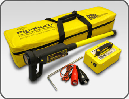
- Superior high frequency (480 kHz) performance. Pipehorn is the best tool in the industry when direct connect is not possible, and on the toughest conductors: coated iron pipes with insulated joints, unenergized power (street/parking lot lights), worn-out tracer tape & wire, short side services & stub-outs, concentric neutrals, and fiber. Nothing sweeps areas for un-marked utilities like a Pipehorn.
- Simultaneous conductive transmission of both high (480 kHz) and low (9 kHz) frequencies for congested areas and for long distance locates (800-HL). Check either signal with the flick of a switch.
- No more air broadcast on high frequency conduction. Better signals on the worst conductors.
- Fast-response signal strength meter and sharp audio tone for precise pinpointing.
- Watertight reinforced receiver wand. More durable than ever.
- All weather / high impact ABS housing on transmitter. Audio tone indicates battery strength and good connection. Low profile (wont tip over). Bright yellow (easier to see).
- Lightweight, space saving carry bag.
- Dual frequency unit with both 480 kHz and 9 kHz for all of your locating needs.
Transmitter
- Frequencies: 480 kHz and 9 kHz (model dependent)
- Modes: Inductive & Conductive
- Battery: 8 “C” alkaline batteries
- On/Off Indicator
- Battery Life Indicator
- Good Signal Indicator
Receiver
- Output: Signal strength meter and audible, built in speaker
- Gain: Smart Control™ (semi-automatic)
- Battery: Two 9-volt
- Weight: 3.4 lbs. (1.5 kg)
Toneable Duct Rodders
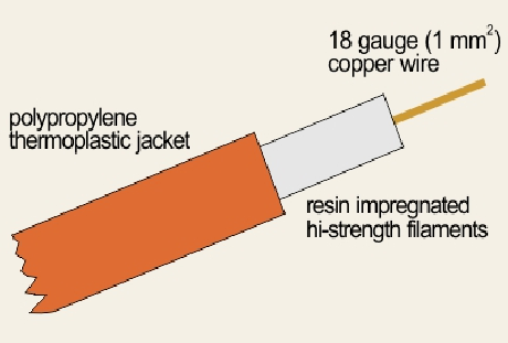
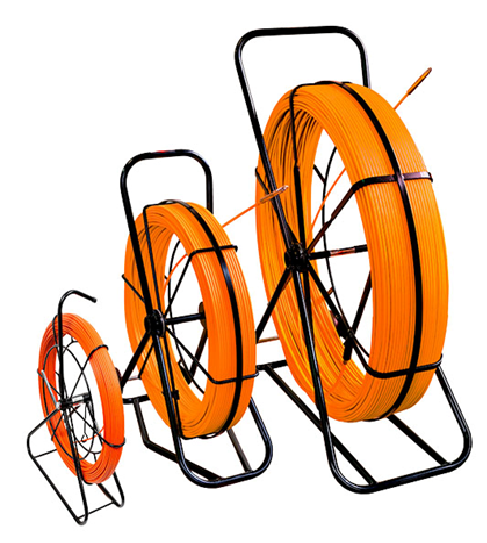
The GMP toneable duct rodders are available in 3/8″ and 1/2 ” diameter. Detectable duct rods are used to find, follow and accurately map the duct route without digging or trenching. The traceable duct rod is used in conjunction with both a signal transmitter and a receiver. The easily identifiable signal is transmitted along the entire length of the duct rod.
The toneable duct rod has an 18 AWG copper wire, almost twice the size of the competition, in the center of the fiberglass core. The copper wire is also connected to the end fittings so the transmitter leads can make a direct connection to the copper wire. The female end fitting provides the attachment point for the transmitter’s lead connection. The other transmitter lead is connected to a stake driven into the earth. The direct connection of the signal to the copper wire provides the most effective method of signal transmission.
Features
• large internal copper conductor
• premium rod material
• can be used with a sonde
Model 501 Tracker™ II Cable Locator System
The Model 501 is designed to locate the path and depth of buried cable, service wires, metallic pipe or conduit and locate the end of a cut cable.
The Model 501 consists of:
- 501T Transmitter
- 501R Receiver
- 500CA Carrying Case with Inductive Antenna
- CS16 Cord Set
- IC-1 Inductive Coupler
The Model 501 is designed to locate the path and depth of buried cable, service wires, metallic pipe or conduit and locate the end of a cut cable.
Transmitter
The transmitter is housed in an aluminum case and is powered by eight (8) 1.5V AA batteries. The transmitter has an on/off control knob which is also used to adjust the output level and a light emitting diode (LED) indicating the battery condition. In addition, the transmitter has an automatic shut-off feature after 1.5 hours of non-use. Effective range is greater than 4000 feet in length and for depths up to 7 feet.
Receiver
The receiver is encased in an aluminum housing, mounted with an antenna and is powered by one (1) 9V battery. Like the transmitter, the receiver will automatically shut itself off after 1.5 hours of non-use. The receiver has a speaker for listening to
the signal, a meter for monitoring the signal level, a headset jack, an on/off volume control knob and an antenna for detecting the tone over the cable.
Carrying Case with Inductive Antenna
The case is used for storing and transporting the Tracker II system and is constructed of vacuum formed polyethylene. The case also includes an easy, quick reference operation guide on the inside of the lid.
Cord Set
An 8 foot pair of leads with plugs and clips is included for connecting the transmitter to the cable or pipe.
Inductive Coupler
The inductive coupler induces a tracing tone on a cable, wire or pipe by clamping around it.
Optional Headset
The headset can be used to monitor the received signal in high noise level areas and is plugged into the receiver jack provided.
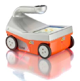
StructureScan Mini XT
Complete GPR system for Concrete Inspection
The StructureScan Mini XT is GSSI’s newest generation of our very popular all-in-one ground penetrating radar systems. The StructureScan Mini XT offers a 2.7 GHz antenna for superior target resolution and can reach depths up to 60 cm (24 in). This system is designed with the option for users to add accessories and tailor the unit to specific applications. With multiple modes of operation, the StructureScan Mini XT is ideal for locating rebar, conduits, post-tension cables, voids and real-time determination of concrete slab thickness.
- Max Depth 60 cm (24 in)
- Antenna Frequency 2700 MHz
- Weight 1.8 kg (4 lbs)
- Storage Capacity 14.5 GB
- Optional Software RADAN 7 for StructureScan Mini
The StructureScan Mini XT is typically used to:
- Find rebar, post tension, conduits, and non-metallic objects
- Measure slab thickness and void location
- Concrete scanning and imaging
- Condition assessment
- Structure inspection
GPR Concrete Scan Equipment (Sub 20" Depth)
StructureScan™ Mini System Components
- All-in-one control unit, 1600 MHz antenna and survey wheel combo
- Dual battery charger
- Two batteries
- Rugged carrying case
- Quick Start Guide
- Training Video
- Sample 3D data collection grid pack (StructureScan Mini 3D)
GPR Specifications
- Memory: Based on SD card size, default is 2 GB
- Display: 5.7″, full-color
- Post-processing: On-screen or via GSSI software (optional)
- Battery: 2.5 hours
- Ports: SD card, USB port
- Environmental: Water-resistant and dust proof (IP-65 rating)
- Languages: English, Spanish, French
- Weight: 1.6 kg (3.3 lbs)
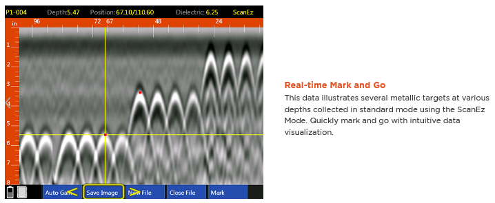
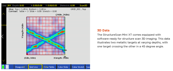
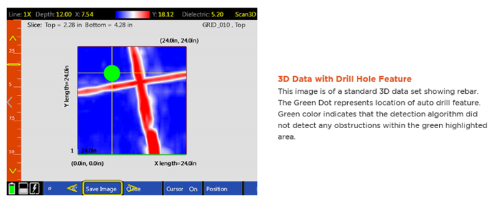
Data Examples
Juniper Systems Sub-Meter GPS
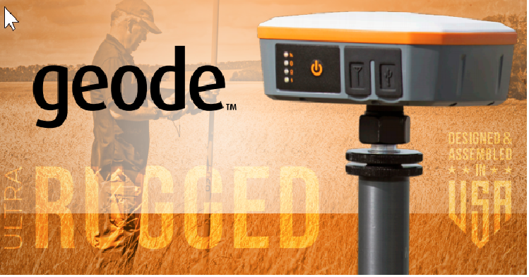
GET REAL-TIME, SUB-METER ACCURACY
- Sub-Meter Accuracy – Collect precision GNSS data with an existing device
- Real-Time Data – Multiple correction sources provide precise, real-time data
- Affordable – Professional accuracy at a budget-friendly price
- Compact Size – Small and lightweight for all-day use
- Open Interface – Works with Juniper Systems’ handhelds or your own device
- Simple to Use – Intuitive and easy operation, one-button simplicity
- All-Day Battery Life – Ideal for long work days
SUB-METER GPS RECEIVER
Looking for a simple sub-meter GNSS solution at an affordable price? With the Geode, you can easily collect real-time, sub-meter GNSS data without the huge price tag or complexity of other precision receivers.
Designed with versatility in mind, the Geode works with iPhone and iPad as well as a wide range of Windows®, Windows Mobile, and AndroidTM devices and is especially useful for bring-yourown-device workplaces. Take the Geode with you mounted on a pole, in a pack, or held in your hand to collect real-time sub-meter GNSS data in harsh environments, using almost any handheld device.

The Mesa 3 Rugged Tablet offers powerful new functionality, while retaining impressive features from the popular Mesa 2 Rugged Tablet. The Mesa 3’s Quad-core Pentium processor is ready to run even the most demanding field data collection application, and its rugged ergonomic design is ready to handle a long day on the job in some of the harshest environments out there. Mesa 2 continues to offer a reliable and robust Windows 10 experience for those needing less processing power. Ready to experience Juniper Rugged?
BUILT JUNIPER RUGGED™
Meeting IP68 and MIL-STD-810G ratings, the Mesa 2 and 3 are waterproof, dustproof, and shockproof. Rest assured rain, extreme temperatures, and dirt won’t stop a productive workday.
POWERFUL PROCESSING POWER
Expect lightning-fast speeds all day long with the Mesa 3’s Quad-core Intel Pentium N4200 processor and large memory capacity. The Mesa 2 operates on an Intel Atorn™ Z3745 processor that provides the power you need to get the job done. Running a full Windows 10 operating system, these devices are made to handle large files and detailed maps.
ALL-DAY USABILITY
From ergonomic enclosures to sunlight-readable displays to 15-hour battery life, the Mesa 2 and 3 are made for long days on the job.
CAREFULLY DESIGNED AND SUPPORTED
These are more than rugged tablets. Designed and assembled in the United States, the Mesa family of devices promises longevity and data protection. If it becomes necessary, each device is proudly supported by live and personalized customer support.
YOUR OFFICE, ANYWHERE.
Sewer Camera "Viper-S" with built-in 512Hz sonde
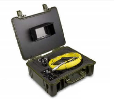
The Viper-S is a 512Hz frequency Sonde located immediately behind the camera head. This makes the tip of the probe traceable with a sonde locator, allowing the operator to determine the exact position of the camera head underground.
The camera head itself contains 12 adjustable white LED lights, to illuminate the inspection area, a flexible spring coiled joint to navigate corners, and a Sapphire lens to resist scratching.
The high resolution CCD chip is designed to capture bright, crisp, color video of the inspection area, and it is integrated into a sewer camera’s straight forward view tip.
The monitor and additional controls are built into a compact, waterproof, lightweight plastic case making it easy to transport. The 7” TFT LCD displays a crisp live color image, with an adjustable sun hood for outdoor inspections.
Insertion Probe
• Length:20 meter(65.6′), 35 meter (114.9 foot) and 40 meter(131.2′)
• Camera Head Diameter: 23mm (1.0″)
• Color CCD camera with sapphire glass lens
• No articulation sewer camera
• Fiberglass cable
• 60° Field of View (FOV)
• 0° Direction of view (DOV)
• Waterproof design
• Illumination: 12 white LEDs
• Special point touch connector to the camera
• Waterproof: IP68
Image Hub
• 7” Color LCD monitor with Video output, file playback
• Monitor Picture Resolution: 320 (TV Lines)
• SD card slot to capture video/images
• Recording format – AVI/JPEG
• Power adaptor: 110~240VAC, 12VDC/1800mA
• Rechargeable battery for portable use up to 3 hours
• Li-ion battery box (4000mAh)
• Operating temperature – 20°F~ 120°F (- 28C°~ 50°C)
• Dimensions: Plastic Carrying Box 48cm x 39cm x 19.5cm
• Total weight: 7.5 kg
Garrett GTI 2500 Pro Metal Detector
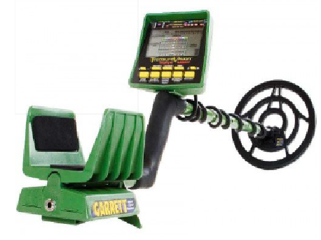
Garrett GTI 2500 Pro Metal Detector with 9.5″ and 12.5″ Imaging Search Coil Plus FREE Metal Detecting & Treasure Hunting Accessories
When you find a coin, the GTI detectors will tell you what kind of coin it is: a penny, a nickel, a dime, a quarter, a half dollar, or a dollar. The GTI 2500 lets you sift out the trash and concentrate on the treasure, making the hunt far more productive than with any other detector manufactured! This is possible thanks to the secret ingredient in the GTI series exclusive Digital Signal Processing (DSP) chip. With some detectors it’s impossible to know whether a detected target is junk or treasure until you dig it up. Because different targets share similar conductivities, detecting what you think is a quarter may well be an aluminum can. The GTI 2500 TRUE size and depth technology enables you to determine whether a detected target is junk or treasure. Dig no more aluminum cans! Garrett’s GTI detectors are the only detectors in the world that provide true size and depth.
Here at Kellyco, we practically wrote the book on Garrett’s GTI 2500. From the very first day the 2500 come off the production line, Charles Garrett personally trained Stu Auerbach (Kellyco President) on all the features of the detector. Stu in turn trained his Test Team members who all “fell in love” with the 2500, which has remained a favorite to this very day. Thousands of hours of in-the-field use with the GTI 2500 has made all of our Test Team and Certified Detector Salespersons true GTI 2500 Experts.
Features:
- Frequency : 7.2 kHz
- Warranty : 2 Year Limited
- Total Weight : 4.6 lbs (2.1 kgs)
- Graphic Target Analyzer : Identifies Target’s Conductivity
- Graphic Target Imaging : Shows True Target Size and Depth
- True Digital Signal Processor : Improves Discrimination Accuracy
- Surface Elimination : Adjustable Search Aid Ignores Shallow Items
- ScanTrack : Optimizes Treasure Signals Based on Search Coil Swing Speed
- Salt Elimination Aid : Eliminate Interference Caused by Wet Salty Sand at Beach
- Automatic Ground Tracking : Detector Automatically Adjusts itself to Ground Mineralization for Optimum Performance
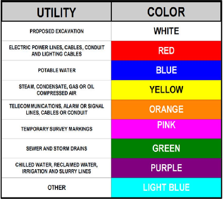
APWA Color Codes for Utility
Infrared Thermography Equipment
FLIR ThermaCAM PM575/595
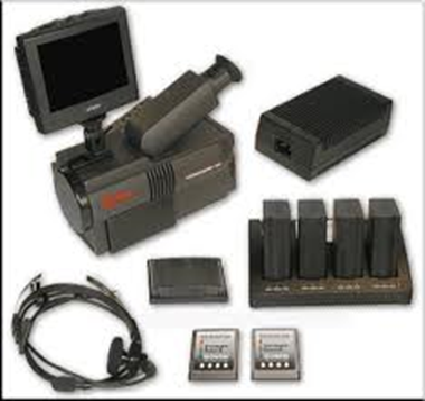
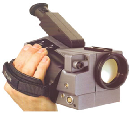
ThermaCAM PM 575/595 offers unique camera and software capabilities to make your predictive and preventive maintenance tasks easier, faster, and more accurate. The ThermaCAM PM 575/595 is a high performance uncooled longwave FPA infrared predictive maintenance system.
- Dust and splash proof, and shock and vibration tested for use in the most demanding field conditions
- Light and operates for more than 1.5 hours on one battery pack
- High resolution color images provide in real-time either in the integral viewfinder or on an external monitor
- Easy to use and operate
The ThermaCAM PM5x5 infrared monitoring system consists of an IR-camera with a built-in 24° lens, a side-mounted digital color camera, a removable battery pack and a range of accessories.
- Dust and splash proof, and shock and vibration tested for use in the most demanding field conditions
- Light and operates for more than 1.5 hours on one battery pack
- High resolution color images provide in real-time either in the integral viewfinder or on an external monitor
FLIR C2 Infrared Compact Thermal Camera
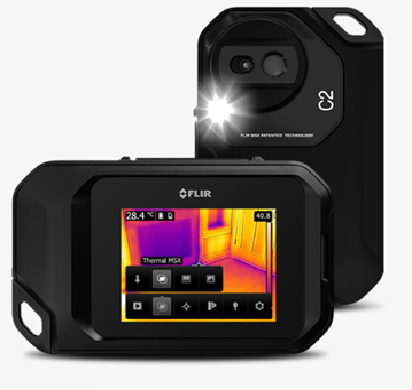
The FLIR C2 is a full-featured, pocket-sized thermal camera designed for a wide range of building and electrical/mechanical applications. Keep it on you so you’re ready anytime to find hidden hot spots, energy waste, structural defects, plumbing clogs, HVAC issues, and other problems. FLIR C2 makes it more affordable than ever to add the powerful advantage of thermal imaging.
Pocket-portable Thermal Imaging
Get the Full Picture
The C2’s generous 45° field of view (FOV) frames in more of the scene, the way the pros see it.
Sensitivity that Shows More
The high-sensitivity detector captures subtle temperature differences and thermal patterns so you can find leaks and building deficiencies.
Full Radiometric Flexibility for Powerful Reports
C2 JPEG images store 4,800 individual thermal measurements you can analyze and edit, using FLIR Tools software.
Moisture Meter GE Protimeter BLD5360
The Dual Mode Pin and Non-Invasive Moisture Meter
Product Highlights
- Protimeter Model # BD5360
- In the measure mode the meter can be used with:
- A two-pin head-and-lead for awkward corners and under work surfaces.
- A set of ‘Deep Wall Probes’ that are insulated except for their tips providing quantitative WME readings at depth, regardless of surface moisture and surface contamination by salts.
- An optional Hammer Electrode (BLD5000) for quick and easy measurement at depth of the moisture content of timber.
- Moisture level values are shown on a digital display alongside a scale of color coded lights that indicate the moisture condition of the material.
Each Unit Includes…
- 5 In. Deep Wall Probes
- Moisture Probe
- Calcheck
- (2) Spare Pins
- Pouch
- Instructions
Rapid, non-invasive and pin moisture evaluation in building materials. Detects moisture directly in materials, such as concrete, and below wall and floor coverings, such as tile, wood and vinyl.
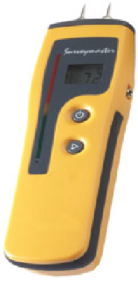
GE Protimeter Surveymaster Specifications
- Measurement Range: 0 to 999 relative (Non-Invasive) / 7% to 99% WME (Pin measurement)
- Display: Display 1 – Digital LCD / Display 2 – 60 LEDs Green (dry), Yellow (at risk), Red (wet)
- Depth of Moisture: Non-invasive up to 3/4″ (19mm) / Pin up to 1/2″ (12.7 mm)